Your map. Your crew. Your safety program. One platform.
Field-Echo is field operations software that carries one record from the estimate to the audit — offline georeferenced mapping, terrain and aerial survey planning, live GPS crew tracking, day planning and production, and a complete health & safety management system — so the crew in the field and the office at the helm work from the same record, with or without signal.
Now onboarding crews • Seismic • Pipeline • Mining • Utilities • Forestry • Civil construction • Events
SEISMIC • PIPELINE • MINING • UTILITIES • FORESTRY • CIVIL CONSTRUCTION • EVENTS
One platform. Two halves that talk to each other.
The Field-Echo mobile app is built for the crew on the ground. The browser-based Command Center is built for the office. Everything syncs between them.
In the Field — the App
Offline georeferenced maps, live location and track history, shift check-in and check-out, waypoints and photos, field-level risk assessments, task hazard analysis, equipment inspections, tailgate meetings, incidents and SOS — all in the crew's pocket, with or without signal.
At the Helm — the Command Center
A browser HQ for estimating and client proposals, day planning and production, live crew tracking, workforce readiness, the Safety Hub, training and certificates, controlled policies, companies and subcontractors, inspections and COR audit evidence — the whole operation on one screen.
Field operations software that works on and offline
Offline Georeferenced Maps
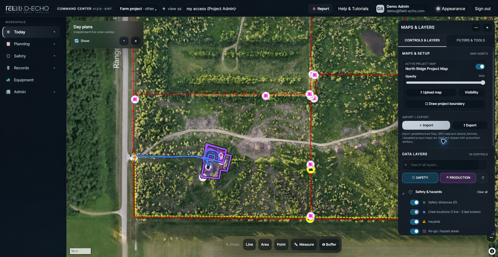
Import GeoTIFF, KML and georeferenced PDF maps, tile them for fast panning, and run them fully offline in the field. Satellite and street basemaps included.
Live Crew Tracking
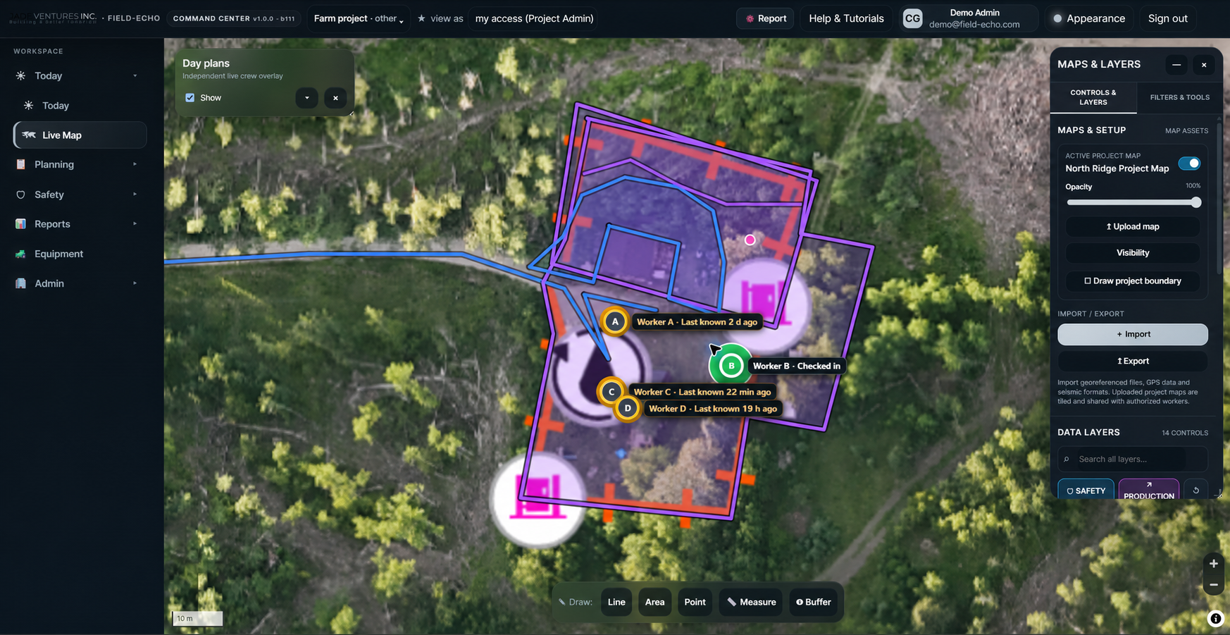
See every crew member on the map in real time — current and last-known positions, track history, shift check-in and check-out, and geofenced zone alerts.
Day Planning & Production
Build the day by crew from a 364-entry task library, draw the work on the map, break tasks into subtasks, and measure planned-versus-actual production as it gets done.
Crew Management & Readiness
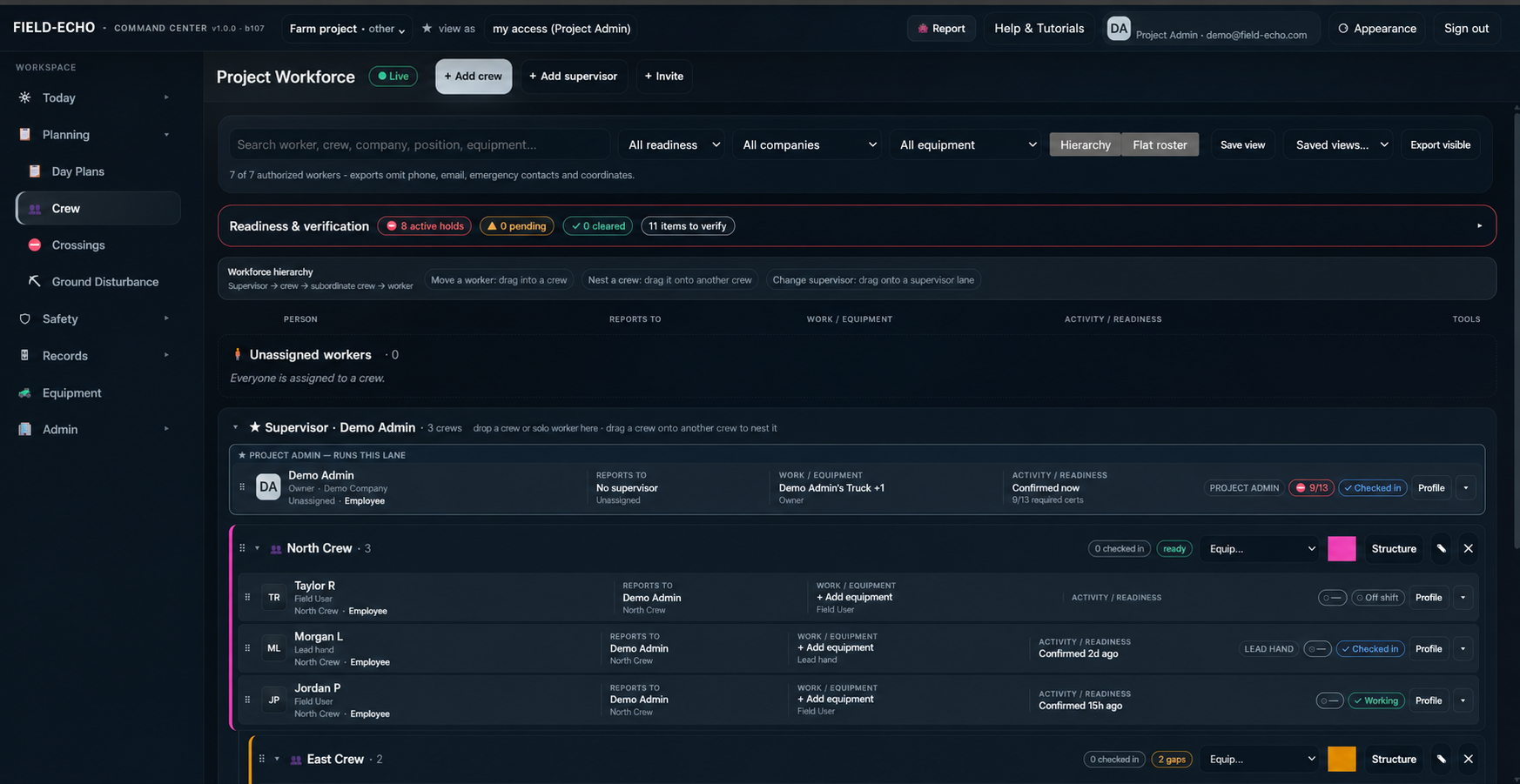
Crews, positions and reporting lines in one place — with equipment in use, shift state, and an at-a-glance view of who's cleared and ready to work.
Hazard & Incident Management
Field-level risk assessments, task hazard analysis, formal hazard assessments, hazard reports with GPS and photos, incidents, corrective actions and stop-work — all backed by a company-reviewed site hazard library.
Equipment & Inspections
526 equipment types with 23 modular pre-trip and periodic inspection templates, red-tag deficiencies that block work until they are cleared, work orders and full maintenance history.
Permits & Clearances
Track crossings, ground disturbance permits and regulatory requirements against the map, so nothing gets worked before it is cleared.
Emergency Response
Muster points, medical resources, hospital routing, emergency contacts and journey management tied to the map — with SOS and check-in from the field app.
GIS & Terrain Analysis
Stack georeferenced project PDFs, satellite, streets, terrain and hillshade in one ordered map, and read DEM-derived slope on a scale set by what actually has to travel the ground.
Aerial Survey Planning
Plan aerial photo missions over the project map, split them into battery legs, set camera angle and photo interval, and export a DJI-ready WPML mission the aircraft flies as planned.
Multi-Project Portfolio
Every project you can see on one board — crews, plans, hazards and open actions side by side — so a manager running six sites can tell which one needs them today.
Reporting & Analytics
Turn field activity into daily production logs, AER-ready reports and client-ready PDF reports with cover, contents and sign-off — with the original field capture preserved behind every number.
Estimating & Client Proposals
Take off quantities on the project map, price them against your own rate books and assemblies, and version the estimate through approval gates. Share a client-ready proposal, capture the response, and carry the awarded scope into the work plan the crew executes.
Companies & Subcontractors
Company profiles, role contacts, insurance, WCB and registration records in one place — with subcontractor relationships, project engagements and mobilisation holds that keep an uncleared company off site.
Roles & Access Control
76 capabilities across 13 role definitions, decided on the server and enforced at the database row — so what a supervisor, a manager or a client can see is the same answer everywhere, not whatever the screen happened to draw.
A complete health & safety management system
Go beyond tracking. Field-Echo builds your health & safety management system into the platform — worker readiness, hazard control, training and certificates, controlled policies, and a COR or SECOR audit you can run against the evidence the work already produced.
Training Matrix & Positions
Build a company position inventory, version the certification requirements for each role against 41 ticket types, and track every worker's status.
AI Certificate Scanning
Drop in a stack of certificates and AI reads, crops, matches and files each one against the right worker and ticket type — with a named human confirming every match.
Preventative Maintenance
Schedule preventative maintenance by calendar date, meter reading or inspection trigger, escalate overdue critical items, and drive defects through to work orders.
Inspections & Form Builder
Build inspection forms, publish immutable versions, assign them across 23 inspection modules and 526 equipment types, and capture results in the field — with critical findings failing closed.
Policies, Procedures & Bulletins
Draft with AI, publish controlled policies through a real approval lifecycle, distribute them by position or crew, and track read-and-acknowledge sign-off. A new version re-triggers acknowledgment automatically.
Online Courses & Certificates
Author courses with lessons, visuals, knowledge tests and expiry dates, assign them by position, crew, project or worker, and issue wallet-size and letter-size printable certificates.
Site Hazard Library
A 693-entry site hazard library across 12 site categories and 7 energy domains — every entry reviewed and approved by your own company before it ever feeds a field risk assessment.
Observations & Competencies
Behaviour-based observations, supervisor coaching and planned task observations across 13 categories feed an 89-competency worker assessment framework, with real evidence behind every sign-off.
Emergency Response Plans
Build and publish a project ERP — muster points and medical resources on the map, on-site medical support kept separate from the nearest hospital, jurisdiction checks, and a controlled PDF you can hand to the client.
Orientations & Onboarding
Company, project and client orientations in one place, brandable to your company, so every worker and visitor arrives on site having completed the right one — with the record to prove it.
Safety Meetings
Run tailgate and safety meetings against the day that is actually planned — the meeting opens with an 86-topic library, yesterday’s reported hazards and today’s scheduled work, and attendance becomes the evidence.
COR & SECOR Audit Management
Run an audit cycle against the ten COR elements — instruments, findings, corrective actions and project sampling — with every finding linked to the effective-dated records that evidence it, and read-only access for the auditor.
See Field-Echo running the day
Real screens from the current build — the live map, Day Plans, project workforce and readiness, Today, and the Safety Hub — shown with anonymized demo data and personal details removed.



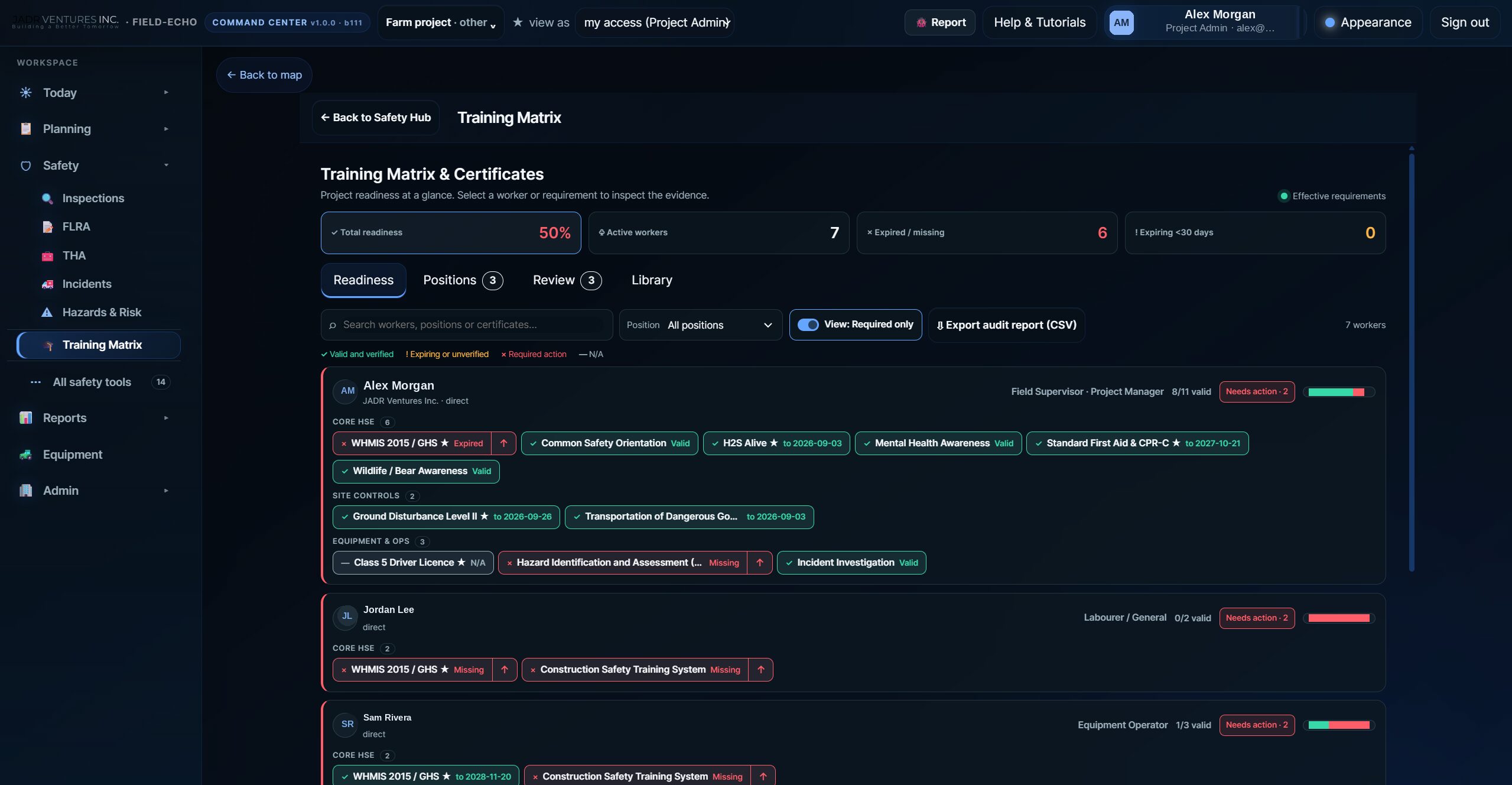
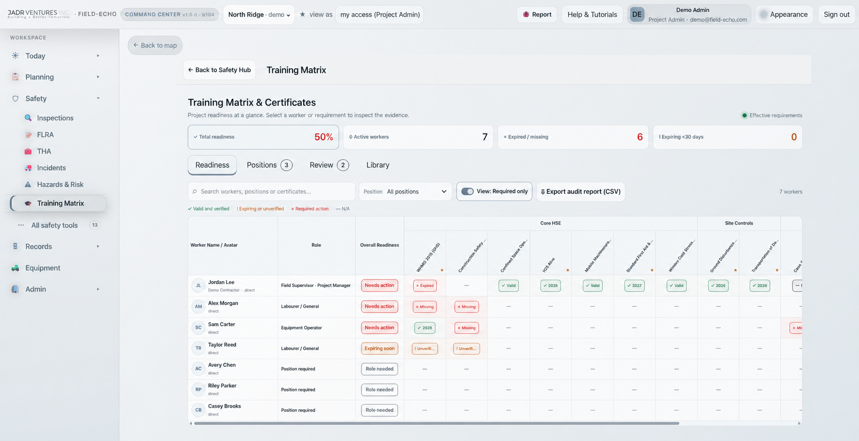
Training matrix · Readiness · Evidence
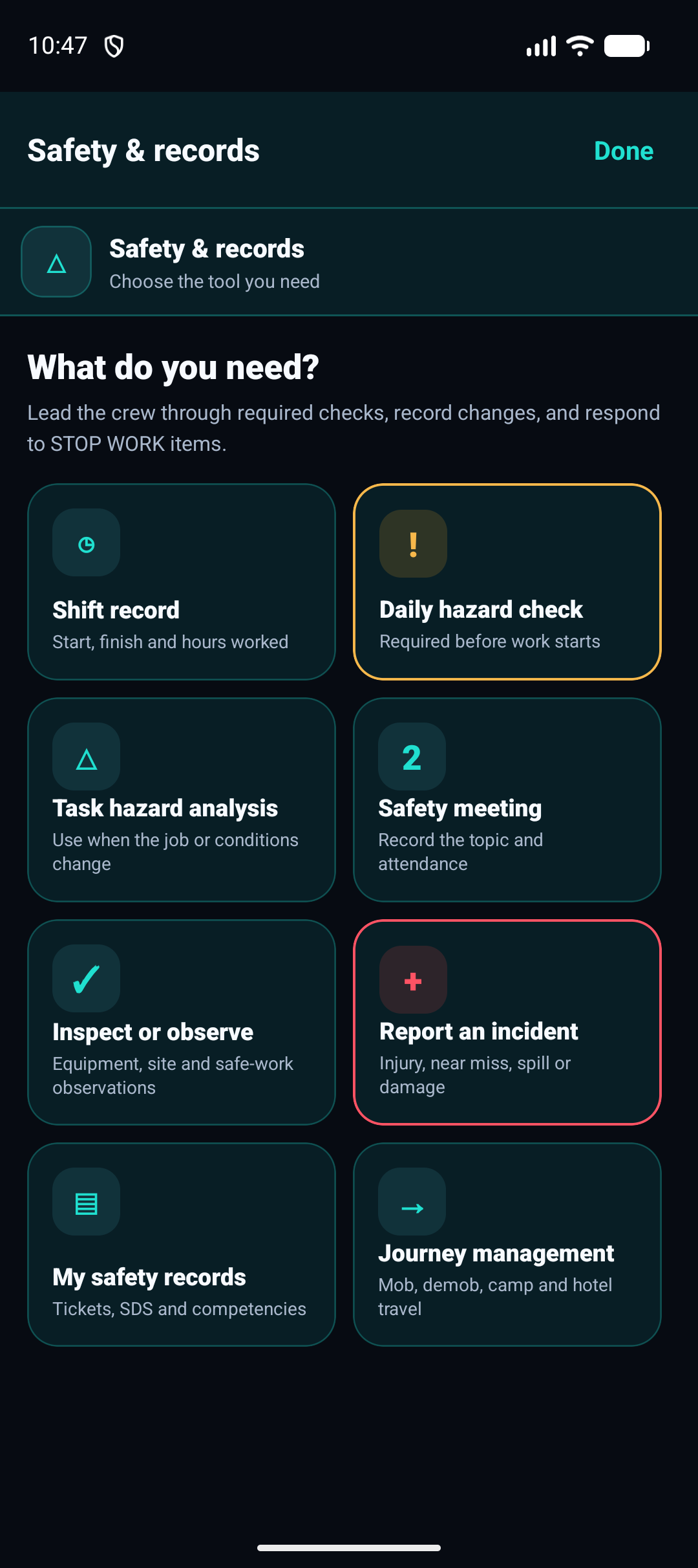
Daily hazard check workspace
Built for demanding field operations
Seismic Exploration
Manage layout and line crews across vast, remote cut lines with offline maps, live tracking, and hazard reporting.
Pipeline
Coordinate right-of-way crews, track progress along the spread, and keep safety and compliance records in one place.
Civil Construction
Plan daily work, track planned-vs-actual production, and manage crew readiness across active sites.
Large Construction Projects
Coordinate multiple crews and subcontractors with shared maps, task assignment, prequalification and engagement records, and consolidated reporting.
Events
Keep event teams and emergency response units connected with live positions, geofences, and in-app comms.
Utilities & Powerline
Coordinate line, vegetation and locate crews across long corridors with offline maps, crossings and ground disturbance permits, and live positions on every span.
Forestry & Silviculture
Run block-based work in remote cut areas — offline maps, crew tracking, daily hazard checks and production records that keep working with no signal.
Mining & Mineral Exploration
Run remote exploration programs — heliportable and low-impact crews, offline maps, terrain assessment before mobilisation, and accountable check-ins where there is no cell coverage.
Don't see your industry?
If your crews work in the field, Field-Echo can work for you. Scroll down to reach out.
Field-Echo questions, answered
Straight answers on what Field-Echo does, how it keeps working with no signal, and how it fits a COR or SECOR safety program.
Getting started
What is Field-Echo?
Field operations software in two connected halves — a mobile app for the crew and a browser Command Center for the office. Maps, day plans, production and your whole safety program run off one record.
Who is it for?
Companies running crews in the field: seismic, pipeline, utilities, forestry, civil construction and events — especially where the work happens outside cell coverage.
What does it cost?
Field-Echo is free to start. Team pricing is set per operation, so request access and we will walk you through what fits.
What devices does it run on?
An Android app and a mobile web app for the field, and the Command Center in any modern browser on desktop or tablet.
Can I build estimates and send a client proposal?
Yes. Take off quantities on the project map, price them against your own rate books and assemblies, version the estimate through approval gates, and share a client-ready proposal. When it is awarded, the scope carries into the work plan the crew executes.
Can I run more than one project at once?
Yes. The Portfolio puts every project you have access to on one board — crews, day plans, hazards and open actions side by side — and you drop into any one of them from there.
Maps & crew tracking
Does it work with no cell service?
Yes. Maps, waypoints, forms and task updates are captured offline and sync as soon as a device is back in coverage.
What map formats can I import?
Georeferenced PDF, GeoTIFF and KML or KMZ, plus satellite and street basemaps.
How is this different from Avenza Maps?
Avenza is a strong single-user map reader. Field-Echo adds the crew around the map — live positions, day plans, production and a full safety program on the same record.
Can I see where my crew is in real time?
Yes: live and last-known positions, track history, shift check-in and check-out, and geofenced zone alerts.
Who can see a worker location?
Visibility is role-based. Managers and supervisors see the crews they are responsible for; workers see what the project is configured to share.
Can I see terrain and slope before I send a crew in?
Yes. Field-Echo derives slope from elevation data and draws it over your project maps, on a scale you choose by what actually has to travel the ground — foot crews, quads, tracked equipment or highway vehicles.
Can I plan a drone survey?
Yes. Plan an aerial photo mission over the project map, split it into battery legs, set camera angle and photo interval, and export a WPML KMZ mission a DJI Mini 4 Pro will fly as planned.
Safety & compliance
Is Field-Echo a safety management system?
Yes. Field-level risk assessments, task hazard analysis, inspections, incidents, corrective actions, training, competencies and controlled policies are all built in.
Does it help with COR or SECOR?
Yes. You can run the audit cycle inside the platform against the ten COR elements — instruments, findings, corrective actions and project sampling — with every finding linked to the effective-dated records that evidence it, and read-only access for the auditor. Certification itself still comes from your Certifying Partner audit.
Can I manage subcontractors and their paperwork?
Yes. Company profiles, role contacts, insurance, WCB and registration records are held per company, with subcontractor relationships, project engagements and mobilisation holds that keep an uncleared company off site.
Can I bring my own certificates and training records?
Yes. Upload a stack of certificates and AI reads, crops and matches each one to the right worker and ticket type, with a named person confirming every match.
Where is my data stored?
In a managed Postgres database hosted in the Canada Central region, encrypted in transit and at rest, with row-level access rules per company and project.
Can I publish an emergency response plan?
Yes. Build the project ERP with muster points and medical resources on the map, keep on-site medical support separate from the nearest hospital, run the jurisdiction checks and publish a controlled PDF.
Can I run site orientations through it?
Yes. Company, project and client orientations are built in and carry your own branding, with a completion record behind every worker and visitor.
Get Field-Echo running on your crews
Tell us about your operation — crews, projects and where the signal drops — and we’ll get you set up with early access. No credit card required.
Get in touch
contact@field-echo.com
What happens next
We read every request ourselves and reach out to get your projects, crews and safety program set up.
Support
Existing customers can reach us any time at the same address.